.jpg)
Granted, I've not yet seen much of what Colorado has to offer, but if this route is any indication of what I will see, I'm in for a fascinating summer.
The San Juan Skyway Loop is a full-circle highway surrounding the San Juan National Forest. My journey started in the town of Dolores, heading north toward the well-known ski resort town of Telluride on the Highway 145.
The Dolores River peeked out now and then, always to my right, as I meandered along the well-paved two-lane road past lucious green pastures and mountainsides thick with aspens and evergreens. Though the road continues, my final destination was Telluride. At some point this summer, I will travel the north side of Telluride over to Ouray.
The pictures on this page were taken along Highway 145. A link will be provided for pictures taken of Telluride. Also, another page of pictures will be of the "other side" of the San Juan Loop, Highway 550 also known as the Million Dollar Highway, from Durango to Ouray. Just follow the links!
.jpg)
.jpg)
.jpg)
.jpg)
.jpg)
.jpg)
.jpg)
.jpg)
.jpg)
.jpg)
.jpg)
.jpg)
.jpg)
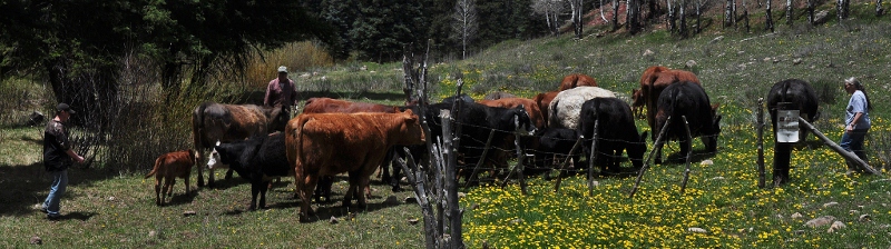
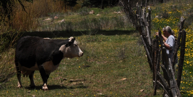
A story: Also, near the Priest Gulch area, I whizzed past this little piece of land filled with yellow wildflowers (left). It was so pretty, I turned the car around to get a picture. A sign there said "Tenderfoot Trail." So, I felt okay about taking off up the trail except that it appeared to be on someone's land, and I wasn't sure whether to park on the road or in the area that appeared to be their private property. A lady and her son happened to be out in the yard, so I asked them where I should park while I walked up a small part of the trail. They said I was fine where I was.
The lady, wearing a long gray and neatly braided pony tail and high rubber boots told me she was getting ready to bring the cows out of winter pasture into spring pasture. She was headed up the trail, so I asked if I would be in the way. She appeared to welcome me along, but quickly forgot I was there.
Without warning, she started yelling to a particular cow, I guess the leader of the herd. And within the minute, a big 'ol fat cow comes lumbering down the side of the hill. Behind it are close to a dozen others of all colors, including a couple calves that couldn't have been a month old. The lady, who seemed to fit the name Nellie, continued hollering, calling and coaxing the cows into a holding area. Once they were all there - and counted - she opened the gate to a larger pasture...the summer pasture.
I watched as she expertly and with great confidence moved among the cows, slapping them on the rears to get them to move along. Her son, a dog and a large burly guy stayed behind to direct any strays.
It was, for me, an unexpected treat that could have been lost had I not turned around. Yep, the journey is the destination.
.jpg)
.jpg)
.jpg)
.jpg)
.jpg)
.jpg)
.jpg)
.jpg)
.jpg)
.jpg)
.jpg)
.jpg)
.jpg)
.jpg)
.jpg)
If you'd like to continue viewing pictures of the San Juan Skyway, click any one of these links. A link on that page will lead you to others.
Highway 550 from Durango to Ouray
Or, you may want to return to the Colorado home page
Or, to a destination below
Please visit some of my other travel locations. Feel free to email me if you have questions or comments.
BY CITY:Boston | Carson City | Coeur d'Alene, ID | Colorado Springs | Duluth, MN | Durango, CO | Fort Benton, MT | Galveston, TX | Independence, MO | Juliette, GA | Leadville, CO | Morro Bay, CA | New York City | Sacramento | San Diego | Savannah | Seattle | Sedona, AZ | St. Louis | Stillwater, MN | Tombstone| Tucson | Washington, D.C.
BY STATE:Alaska| Arizona | California | Colorado | Georgia | Idaho | Maine | Michigan | Minnesota | Montana | Nevada | New Mexico | North Carolina | Oregon | South Dakota| Texas | Utah | Washington | Wisconsin | Wyoming
BY REGIONS, LANDMARKS AND NATL PARKS, FORESTS AND MONUMENTS: the Ancient Bristlecone Pine Forest | Antelope Island on the Great Salt Lake | Arches NP | the Badlands | Big Sur | Bighorn Canyon | the Biltmore Estate | the Black Hills | Blue Ridge Parkway | Bodega Bay | Bridges of Madison County | Bryce Canyon | Canyon de Chelly | Canyonlands NP | Death Valley | Devils Tower| Garden of the Gods | Glacier NP | the Grand Canyon | the Grand Tetons | the Great Sand Dunes NP | Gulf Shores, AL | the Hearst Castle | Highway 287 | Hoover Dam | Hovenweep NM | In search of Barns and Bridges | Kure Beach | Lake Powell | Lake Tahoe | Little Bighorn Battlefield | Mackinac Island | Martha's Vineyard | Medicine Bow NF | Mesa Verde NP | Monterey Bay | Monument Valley | Mount Rainier | Mount Rushmore | Mount St. Helens | Napa Valley | Natural Bridges NM | Niagara Falls | OK City (bombing) NM | the Olympic Peninsula | Organ Pipe Cactus NM | the Outer Banks | the Petrified Forest and Painted Desert | Pictured Rocks NL | Point Reyes Natl Seashore | Rocky Mtn NP | the Royal Gorge | Saguaro NP | Shenandoah Valley | Sleeping Bear Dunes NL | the Sonoma Coast | Sunset Crater NM | Texas Hill Country | Tonto NM | Tonto Natural Bridge | Tybee Island | Valley of Fire | the Vermillion Cliffs | White Mountains NF | Yellowstone NP | Yosemite NP | Zion NP
OUTSIDE THE U.S.: Austria | Budapest, Hungary | Canada | Costa Rica | East Africa | Europe, here and there| France | Germany | Greece | Italy | Morocco | the Netherlands | Portugal | Puerto Peñasco, Mexico | Russia | Scotland | Spain | Switzerland | Tunisia | Turkey
OTHER: HOME |My Favorites | the Andreas family, Moab | Vilseck DoDDS teachers' reunions | Madi's Page
All images within 'The Wandering Chick' Web site are copyright protected. They may not be downloaded or otherwise copied.
.jpg)
.jpg)
.jpg)
.jpg)
.jpg)