the wandering chick
...the Colorado National Monument
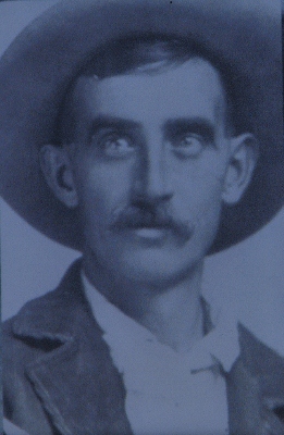
It was the efforts of one man, John Otto, who loved the area of the Colorado National Monument so much that he spent four years of his life in the early 1900s promoting it and fighting to get it recognized as a national park. With the support of the residents of Grand Junction, who flooded Washington, D.C. with letters and petitions, the area in 1911 was established.
But that's not all Otto did. While all this was going on, he used his own physical efforts to build miles of trails throughout the park so that others could appreciate it.
Otto was named the park's caretaker, a task he took seriously until 1927. That job earned him $1 per month.
The Colorado National Monument is located southwest of Grand Junction, Colorado. The main road, Rim Rock Road, travels 23 miles from the south entrance to the west entrance at Fruita. It has many named overlooks along the way and several trails, long and short. A Visitor Center is located a few miles in from the Fruita entrance.
Thank you, John Otto
I think I see a queen's profile in this rock formation.
These, of course, are not working coke ovens, but over the ages, wind, water and ice have formed these massive rocks to a shape similar to coke ovens, once used to transform coal into coke. The formations can be seen from several of the overlooks on the Rock Rim Road.
Taken at the Artists Point Overlook
One of several canyons within the big canyon of the Colorado National Monument is this one, Red Canyon.
Taken along the Coke Ovens Trail. This is a short half-mile trail that leads out to the Coke Ovens. It's a nice trail to walk, but you get a better view of the coke oven rock formations from the overlook on the road. In the photo on the right are the coke ovens, and you can see a person standing at the platform where the trail ends..
.jpg)
The magnificent Utah Juniper trees and their characteristic gnarly forms can be seen throughout the park. (And I probably took a picture of everyone of them!)
Above and Below, Left: Taken from the Monument Canyon Overlook
Some of the most interesting rock formation are in Monument Canyon, pictured here. The picture on the left is a close-up of this rock formation. Clearly, a door seems to be built into the rock. Rock discoloration is normal and is caused by various factors.
The rock formation to the right is Independence Monument, and in front of it (to its left) is Wedding Canyon. Out of the picture and behind Independence Monument is Monument Canyon. It's believed that the monument is actually all that is left of a wall that separated the two canyons.
A slab of the canyon wall at Artists Point
This is Independence Monument. John Otto scaled the monument in celebration of President William Taft naming the park a national monument in 1911. Tradition has carried on ever since, and climbers on the Fourth of July will scale the structure and, also traditionally, raise the American flag.
Another view of Independence Monument, from a slightly different angle. "Indy" is 450 feet high and is the most distinctive formation in the park.
In Monument Canyon
The Book Cliffs is a mountain range that runs east to west for some 200 miles in Utah and western Colorado. They can be seen from most viewpoints in the park and from the Colorado River Valley, seen here.
Another distinctive rock formation is called the Kissing Couple, in Monument Canyon.
Monument Canyon, with Independence Monument in the center
Rock Rim Road winds down into Fruita on the parks northwestern side.
Rock Rim Road passes through a couple of tunnels as it descends into Fruita on the northwest side.
Window Rock can be seen from the Book Cliffs View where there is a short hike to get a scenic overview of Monument Canyon.
A bus climbs into the park via Rock Rim Road as it heads from Fruita to the park's south entrance.
If you'd like to visit more areas of Colorado, please return to the Colorado home page.
While in Grand Junction, I also visited the Grand Mesa, a wonderful day trip, especially since the fall leaves are beginning to appear. To see that set of photos, click here.
Balanced Rock is the last named formation you might see as you leave the park at Fruita.
Thank you for visiting these photo pages.
If you're interested in seeing more, please return to the Main Menu at the bottom of my home page and make your selection.
All images within 'The Wandering Chick' Web site are copyright protected. They may not be downloaded or otherwise copied.
Please contact me if you think a particular photo or set of photos can be used in your publication.
This is a view of the Colorado National Monument taken from Highway 65 as you descend off of the Grand Mesa. It lies to the northwest.
.jpg)
.jpg)
.jpg)
.jpg)
.jpg)
.jpg)
.jpg)
.jpg)
.jpg)
.jpg)
.jpg)
.jpg)
.jpg)
.jpg)
.jpg)
.jpg)
.jpg)
.jpg)
.jpg)
.jpg)
.jpg)
.jpg)
.jpg)
.jpg)
.jpg)
.jpg)
.jpg)
.jpg)
.jpg)
.jpg)